The interpretation of a geographic landscape as a geosystem requires evidence that, under certain conditions, an external signal has a similar response in its spatial elements. The article examines the similarities and differences in the response of units in the steppe landscape of the Southern Urals (Burtinskaya steppe) to varying hydrothermal conditions. The Normalized Difference Vegetation Index (NDVI) is used as an indicator of in- tra-seasonal variability in phytoproduction performance. 110 standardized increments of NDVI during the growing seasons in 2010–2020 were ranked and interpreted as types of dynamics in comparison with background modal values. The occurrence and diversity of types of phytomass dynamics within the model units (gullies, ridges, and interfluve flat surfaces) vary depending on hydrothermal conditions and the length of the time interval between measurements. The integrity of the unified response in the landscape is enhanced during dry periods, when changes in phytomass in gullies and on ridges differ little from those on spatially dominant slopes and flat surfaces. Strong deviations from the background dynamics often appear at intervals of up to 2 months, but are compensated for within 4–5 months. The dynamics of hydrothermal conditions over the entire growing season manifests itself in phytomass changes in a similar way over the landscape, which proves the connection between the spatial and temporal parameters of landscape organization. Depending on the landform, phytocenoses adapt to the late summer moisture deficit either by transitioning to another stable state of structure while maintaining the intensity of functioning (self-organization), or by maintaining the structure while reducing the intensity of functioning (self-regulation).
Introduction
The spatio-temporal organization of geosystems has long been recognized as the main subject of landscape science and landscape ecology [1, 2]. Since the 1980s it is known that interactions between landscape components are possible only when their characteristic time scales are comparable [3–5]. A regular relationship has been established between the characteristic time scales of geosystem processes and the characteristic space scale of their manifestation [3, 6]. Since the geographical landscape is usually interpreted as a geosystem [1], evidence is required that, under certain conditions, an external signal is perceived in a similar way by the spatial elements of this geosystem. This would mean that the landscape responds to external influences as a holistic entity. From a practical point of view, this means the predictability of the behavior of the landscape parts following any strong changes at a regional or global scale. The response to climate changes is most often the subject of research. One of the informative indicators of the landscape state has long been considered its bioproductivity, which sensitively responds even to short-term changes in hydrothermal conditions. Bioproductivity studies are labor-consuming [7]. However, the development of space technologies has provided convenient and affordable means of studying the spatial organization of bioproductivity in the form of numerous indices calculated by means of geoinformation systems based on multi-band satellite images. Among them, the normalized difference vegetation index (NDVI) has become the most popular. This index is most often used to identify trends in phytomass over long-term periods, especially over the past 40 years, which were marked by significant warming in many regions. Less commonly, it is used as an indicator of short-term variability in phytoproductive functioning.
The range of possible states and variants of transition from one state to another can serve as a relevant indicator of the landscape stability types, its adaptation to the range of fluctuations in external conditions (including climate or anthropogenic loads). The definition of a geographical landscape includes a single climate [8, 9]. Consequently, fluctuations in the hydrothermal conditions, characteristic of the regional climate, are expected to find some response in all spatial units of the landscape. If most spatial units of a territory pass
from one state to another in approximately the same way, then such a territory may be considered as a holistic entity. At the same time, a genetically-uniform geographical landscape, by definition, is a mosaic territory. Mosaic is explained by internal processes in the landscape, primarily geomorphological ones [1]. Therefore, the question of the relationship between internal mosaicity and the possibility of a holistic response to external influences is of particular interest. With the obligatory originality of the “behavior” of each element of the landscape mosaic, there must be some unity of their reaction to external signals.
Steppe landscapes are particularly sensitive to interannual and intraseasonal fluctuations in hydrothermal conditions, which are expressed in the phytomass values. The usual seasonal rhythm of the steppes is well known. In involves the maximum accumulation of phytomass in the first half of summer and its reduction in the second half, accompanied by a pause in the vegetation of many species [10, 11]. In space, the slightest variations in soil moisture supply are well-reflected in the species composition of the phytocenosis. The dynamic characteristics of phytomass, which are subject to the phenological rhythms of dominant species and intra-seasonal hydroclimatic fluctuations, can indicate soil hydrology parameters. Therefore, one may consider the steppes as a convenient testing ground for studying the question to what extent and under what conditions the landscape mosaic is consistent with or contradicts the assumption of the landscape integrity.
More than 30 years ago, V.A. Bokov [5] developed a classification of geographical landscape integrity types, one of which he called the integrity of the unified response. This type of integrity is the focus of our study, carried out on the example of a low-mountain-steppe landscape in the Russian part of the Southern Urals.
By holistic functioning, in this study, we mean the subordination of most landscape units over a certain time interval to the same type of phytomass dynamics, indicated by NDVI values. The unity of the type of dynamics was understood as a change in phytomass by approximately the same value following a change in the background hydrothermal conditions that are common for the whole landscape.
In the study, we sought answers to the following questions. 1) How integral is the functioning of the landscape unit in different hydrothermal conditions? If there is a unified reaction of phytomass to hydrothermal changes, is it close to the background modal dynamics of the entire landscape or different from it? Under what conditions can a landscape unit function independently of a most part of a landscape? 2) How do the reactions of the structure and functioning of the phytocenosis in various units differ with increasing moisture deficit? 3) Is there a relationship between the occurrence of local deviations from the modal phytomass dynamics and the duration of the time interval between NDVI measurements?
Experimental
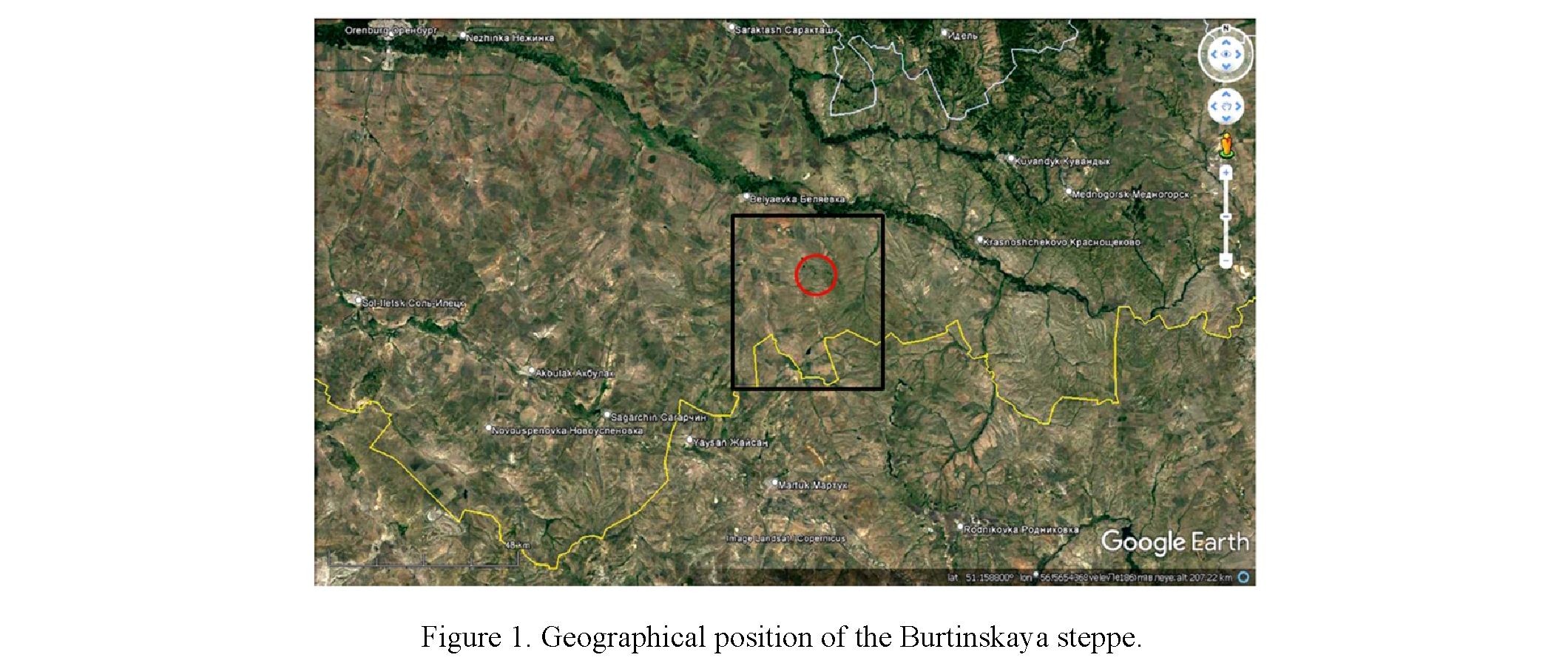
The study was carried out in the Burtinskaya steppe, located in the Belyaevsky district of the Orenburg region of Russia. It occupies the interfluve of the left tributaries of the Ural river — the Urta-Burtya and Bur- lya rivers (Fig. 1).
Note –– The black rectangle is the area for calculating NDVI-based indices. The red circle is a place for field research
in the Orenburg Nature Reserve. The yellow line is the border between Russia and Kazakhstan. Space image: Google Earth
193
Part of the territory belongs to the section of the Orenburg State Nature Reserve. The territory is located in the continental sector of the typical steppe subzone. The landscape belongs to a foothill deeply dissected structurally erosive elevated plain composed of Permian-Triassic conglomerates and sandstones. Typical steppes with dominance of Stipa zalesskii, Festuca valesiaca, and forbs are formed on Calci-Glossic Chernozems and Lithozems [12–14]. On the slopes of elevated massifs, gently sloping ridges with steppes alternate with gullies dominated by shrubs and forbs. In the most deeply incised gullies birch-aspen thickets occur. The low hypsometric level is occupied by accumulation and denudation-shaped plains. At the foot of the massifs, a large area is occupied by gently-rolling plains, dissected by shallow gullies. In the wide flatbottom valleys and along streams, sedge and reed meadows occur as well as black alder forests on Gleyic Chernozems. In some sites, there are galophytic communities on Solonetzes and Solonchaks.
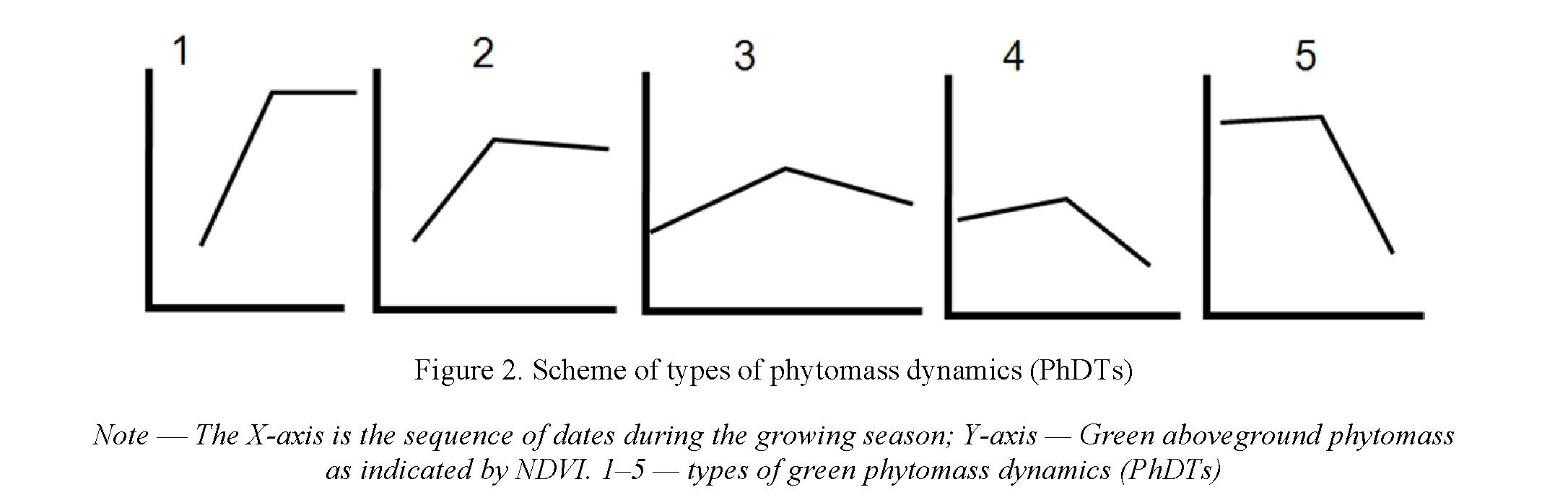
To study the intra-seasonal dynamics of NDVI as an indicator of green aboveground phytomass, we used 50 Landsat 5 and Landsat 8 satellite images with a resolution of 30 m from 2010 to 2020, covering the period from April to October. The further calculation included 1381765 pixels in an area of 1243 km2, including protected and agricultural areas (Fig. 1). We calculated differences in NDVI values between all possible imagery dates of one year: earlier NDVI minus later NDVI. Totally, difference values for 110 pairs of dates were obtained. At the next step the original algorithm [15–17] was implemented. It allows one to relate the modes of functioning in time to the landscape spatial pattern and establish ratios of factors acting at different scales. The resulting estimates do not depend on inter annual fluctuations in phytomass, since the basis is standardized increments of phytomass between two dates. The values of NDVI increments standardized for each pair of dates were recorded into five gradations. The gradations reflect the degree of deviation from the background NDVI increment, that is, deviation from the modal range of values, which in all cases turned out to be close to the average value in the landscape. Hence, they reflect the degree of deviation from the modal response of the landscape to seasonal climatic rhythms. Below, these gradations are referred to as the phytomass dynamics types (PhDT). The sense of dynamics types is as follows (Fig. 2). PhDT 1: Strong deviations from the background dynamics of more than 1.5 standard deviations from the average landscape increment in the negative direction. PhDT 5: The same with a positive deviation from the mean. PhDT 2: Slight deviations from the background dynamics within 0.5–1.5 standard deviations in the negative direction. PhDT 4: The same in the positive direction from the average. PhDT 3: Background dynamics, 0.5 standard deviations either side of the mean increment over the landscape. The background increment (PhDT 3) was interpreted as subordination to the seasonal dynamics of weather conditions, which is the same for the entire landscape, and the low contribution of local conditions for the water and nutrients migration. Large deviations (PhDTs 1 and 5) and small deviations (PhDTs 2 and 4) from the background increment were interpreted as a significant contribution of local factors that distort the landscape-scale rule. The probability of each PhDT for each pixel was calculated. Based on the set of probability values of five PhDTs, the measure of instability (H) was calculated using the Shannon formula. The higher the measure of instability H, the more often five PhDTs replace each other over a period. The maximum value of H is achieved with the same repeatability of five PhDTs, the minimum — in the presence of only one PhDT. The general regularities of the spatial distribution of PhDTs and H in the Burtinskaya steppe were described in our previous publication [18].
To get insight into the mechanisms of functioning stability, we performed a study at three transects and in a group of analogous units on the interfluves. Three transects differ in landscape pattern and together
Серия «Биология. Медицина. География». № 2(106)/2022
characterize all the main variants of the landscape diversity in the Burtinskaya steppe. At each transect descriptions of landscape and geobotanical characteristics were recorded at a regular step of about 30 m. They cover adjacent pixels of a satellite image, provided by calculations of frequency of each of the five PhDTs and H. Transect 1 (“ridges and flat-bottom valleys”): from the upper reaches of the gully to the watershed with the intersection of the south-facing and north-facing slopes and two flat-bottom valleys (19 sites). The transect 1 contains almost all types of units of the Mueldy massif. Transect 2 (“gully”): bushy gully 2–5 m deep cutting the northwest-facing slope of the Mueldy massif (17 sites) and one background interfluve unit above the catchment depression. Transect 3 (“ridges and saddles”): along a ridge-like surface in the northwestern part of the Mueldy massif between two valleys with the intersection of several saddles (19 sites). As the fourth model group, the analogous zonal steppe associations of flat interfluve surfaces were considered [14]. For each transect, we calculated the occurrence of each PhDT for each pair of dates and a measure of the spatial diversity of PhDTs according to the Shannon formula.
The obtained occurrence values for each PhDT and their diversity on transect for each pair of dates were examined for correlations with the hydrothermal indicators of each year and the period between each pair of dates. To characterize hydrothermal conditions we used the average annual and monthly temperatures and precipitation, as well as the Selyaninov hydrothermal coefficient base on the data of the nearest meteorological station Belyaevka. To assess the relationships between the integrity of the functioning of a landscape unit and hydrothermal conditions, the years from 1960 to 2020 were classified by standardized monthly and average annual temperatures and monthly and annual precipitation. Four 4 categories were distinguished: warm mid-humid, cool humid, hot dry and cold wet years. We used analysis of variance (ANOVA) to test the hypothesis that the occurrence of PhDTs on transect may vary depending of hydrothermal conditions of a year. Spearman correlation coefficients were calculated to evaluate the dependence of the occurrence and diversity of PhDTs on the duration of the period between NDVI measurements.
The research focused on the following issues: a) phytocenotic mechanisms of each of the five PhDTs; b) hydrothermal conditions for the integral functioning of landscape units; c) hydrothermal conditions for the subordination of a group of studied units to a holistic mode of landscape functioning (i.e., the predominance of the background 3rd PhDT in the absolute majority sites). A high occurrence of one PhDT and a low diversity of PhDTs were treated as an indicator of the integral functioning of a landscape unit.
Results
Field interpretation of the PhDTs showed the main reasons for the variation in phytomass increments relative to background modal values (Fig. 2).
The lowest values of the instability measure H were achieved, as a rule, due to the predominance of background dynamics (PhDT 3) both at short (up to 2 months) and long (3–5 months) intervals between NDVI measurements. This is typical for elevated plateaus, low-level accumulative plains, and gentle slopes of low mountains dominated by Stipa zalesskii, Festuca valesiaca, Helictotrichon desertorum, and xeroph- ilous forbs. Using the time series of ground-based measurements of the phytomass in 12 communities for the growing season 2015–2020 [14] we obtained a positive correlation between the NDVI for the corresponding date and the phytomass indicators, namely, aboveground green phytomass, green phytomass of forbs, green phytomass of Poaceae species (especially in July), and the ratio of green phytomass to dead aboveground mass. Spearman correlation coefficients in the summer months accounted for 0.5–0.7.
The highest instability of PhDTs (H) were achieved in gullies due to a regular switch between PhDTs 2 and 4, as well as periodic manifestations of background dynamics (PhDT 3) and maximum deviations from it (PhDTs 1 and 5). In spring and early summer, phytomass accumulation occurs at a higher rate than in the background steppe conditions (PhDTs 1 and 2). It is replaced by a rapid decrease in phytomass in the second half of summer and autumn at a higher rate than in the background steppe conditions (PhDTs 4 and 5). Such a change is explained by the short duration of the action of the local factor, namely — high soil moisture within 30–60 days after the spring snowmelt. In the second half of summer, the effect of this factor ceases. The thaw moisture in the soils becomes depleted, while summer precipitation is spent on physical evaporation. Since the dominant plant species of mesophytic communities (Calamagrostis epigeios, Sanguisorba officinalis, Trifolium media) are not adapted to the rapid drying of the soil, the phytomass is sharply reduced.
PhDT 1 corresponds to a rapid spring and early summer accumulation of a large phytomass in meadow communities without its subsequent sharp decrease in the second half of summer. During the entire growing season, a strong local factor of sufficient soil moisture acts. As a result, the phytomass is practically preserved or decreases much less than in the background steppe landscape. The species composition is dominated by Phragmites australis, Carex sp. In phytocenoses Galium aparine, Lavatera thuringiaca, Lythrum sali- caria, and Sium sisarum are typical. Soils are distinguished by powerful humus accumulation (up to 50–70 cm) and gleyization in the lower horizons.
PhDT 5 is never dominant throughout the growing season. It manifests itself almost exclusively in the second half of summer in the form of a maximally sharp (compared to modal values of the landscape) decrease in green phytomass. Such phytomass dynamics corresponds to the termination of the action of a strong short-term local influence of excessive soil moisture supply. The period of significant accumulation of phytomass in gullies and valleys is associated with the intensive development of leaves of trees and shrubs (Salix sp., Populus tremula, Amygdalus nana, Cerasus fruticosa, Spiraea crenata, S. hypericifolia, Genista tinctoria), as well as spring-flowering herbaceous plants characteristic of such habitats plants (Pulsatilla patens, Anemona sylvestris, Tulipa biebersteiniana, Fritillaria meleagroides, F. ruthenica). The drying up of temporary streams and a decrease in soil moisture reserves results in the disappearance of spring-flowering species from plant communities and in a decrease in the productivity. Quantitatively this process is reflected by a high H value and a sharp decrease in NDVI in gullies with short-term spring moisture supply. In larger, deeply incised gullies and along the bottoms of valleys, accumulation of large phytomass in spring and early summer is not replaced by its sharp decrease in the second half of summer (PhDT 1), probably due to the conservation of phytomass by trees and shrubs. A sharp decrease (PhDT 5) occurs only in October due to changes in the composition of leaf pigments and leaf fall. Such changes in the PhDTs are realized in the bottoms of the valleys and the most deeply incised gullies, where the snow cover can persist until the beginning of May.
A study of a shrubby (Spiraea hypericifolia, Cerasus fruticosa, Amygdalus nana) gully on a transect 2 showed that the unity of the phytoproductive functioning regime may be disturbed by differences in the intensity of moisture and nutrients circulation. From the middle incised part of the gully upward to the catchment depression, xeromesophytes (Elytrigia repens, Filipendula vulgaris, Melampyrum arvense, Phleum phleoides, Pulsatilla patens, Seseli libanotis) are gradually replaced by mesoxerophytes (Artemisia mar- schalliana, Centaurea marschalliana, Falcaria vulgaris, Galium ruthenicum, Hieracium virosum, Phlomis tuberose, Poa transbaicalica, Scorzonera austriaca, Serratula cardunculus, Veronica incana) and xerophytes (Stipa lessingiana, Stipa zalesskii, Artemisia austriaca, Galatella villosa, Festuca valesiaca). This corresponds to an increase in the frequency of background dynamics (PhDT 3) at time intervals of 2–4 months (type 3), zero frequency of large deviations (PhDT 1 and 5), and a decrease in the frequency of small deviations (PhDT 2 and 4). The upper reaches of the gully differ from the background dynamics, as a rule, only at short intervals up to 1–2 months.
The bottoms of narrow gullies are characterized by increased accumulation of snow in winter due to wind-induced transport and slower (compared to slopes) melting in shaded positions in spring. This ensures a high level of groundwater and surface runoff in May and June when heat supply is high. Therefore, meadow communities increase their phytomass in spring and early summer much faster than the background steppe (PhDT 1). In the second half of summer, adaptation to the increasing moisture deficit and falling groundwater level is manifested in a sharp reduction in phytomass (PhDT 5) without changes in species composition. The background dynamics (PhDT 3) at long intervals (April-October) appears occasionally, in hot dry years (2010, 2019) or manifests itself at short 1–2-month intervals. The larger the catchment area is, the higher the repeatability of (PhDT 1) dynamics in the gully bottoms.
The saddles are characterized in April by the development of ephemeroids (Pulsatilla patens, Adonis wolgensis, Fritillaria ruthenica, Tulipa biebersteiniana, and Tulipa gesneriana) quickly creating a large mass. Summer losses of phytomass (PhDT 4) due to their death turn out to be greater than the modal ones. The degree of instability is higher than on the slopes due to the more frequent manifestation of strong phytomass losses compared to the modal conditions of the landscape. Under extreme dry summer conditions, the communities adapt by a large reduction in phytomass of the dominant grass species (Stipa zalesskii, Festuca valesiaca, and Agropyron cristatum).
On the south-facing steep slopes in the second half of summer, an increased abundance of Artemisia austriaca and Galatella villosa with a small (45–40 %) projective cover contributes to the partial preservation of phytomass (PhDT 2). The phytocenosis adapts of the to the summer depletion of soil moisture by the replacement of species, i.e. structural changes.
On the steep west-facing slopes, the phytomass dynamics during the period from May to September does not differ from the landscape background trends. Other PhDTs (2 and 4) occur only at short intervals; at longer 4–5-month intervals, the background dynamics is restored.
On the tops of hills with petrophytic conditions, the deviation from the background dynamics at long 4– 5-month intervals (May-September) may be manifested in a relatively small summer decrease in phytomass (PhDT 2). The phytocenosis adapts to moisture deficit by a decrease in the projective cover with a steady dominance of Festuca valesiaca, Artemisia austriaca, and Stipa lessingiana.
In flat bottoms of gullies and at the footslopes, an increase in the proportion of mesoxerophytes and mesophytes (Bromus inermis) is accompanied by a sharp drop in phytomass by the second half of summer. The strategy of adaptation is to reduce the phytomass of dominant species without changes in species composition. However, at a greater distance from the footslopes, a decrease in the abundance of mesoxerophytes and Bromus inermis results in the dominance of background dynamics with a moderate summer decrease in phytomass.
At the next step, we tested the hypothesis about the unified reaction of the Burtinskaya steppe landscape to the weather conditions of a year, i.e. about the integrity of the unified response (sensu [5]). In general, in the landscape of the interfluve of the Urta-Burtya and Burlya rivers, the most integral functioning (the minimum variety of PhDTs) is typical for hot dry years. To understand the reasons, the issue was studied in details in three groups of landscape units provided with pixel-by-pixel descriptions of the phytocenosis.
On transect 1 (“ridges and flat-bottom valleys”), an increased occurrence of background PhDT 3 with a reduced occurrence of small deviations (PhDTs 2, 4) was typical for warm, moderately humid years (2013, 2015, 2016, 2017, 2020). In cool wet years, the diversity of PhDTs increased over a time interval of more than 3 months. Different types of units (gullies, flat-bottom valleys, interfluves, north- and south-facing slopes) reacted differently to increased moisture. Hence, the integrity of unified response was lost by a landscape.
On transect 2 (“gully”) in the hottest dry years (2010, 2012, 2014, 2019), at time intervals of more than 2 months, the occurrence of background dynamics increased (PhDT 3), the occurrence of large deviations from it (PhDTs 1 and 5) sharply decreased. Small deviations from the background dynamics manifested themselves mainly at short intervals of less than 2 months. For example, in July-August of dry 2010, most of the phytocenoses were in the mode of strong phytomass loss (PhDTs 4 and 5). The minority was in the background mode. None of the phytocenoses preserved the phytomass despite increased moisture in the concave landform. In the same period of wet 2018, the variety of PhDTs was minimal, but of a different kind. The synchrony of functioning was manifested in the deviation from the background dynamics towards increased resistance to the summer pause of the vegetation of the steppe landscape. PhDT 2 with a relatively small loss of phytomass prevailed. This indicates favorable conditions for mesophilic and xeromesophilic forbs.
On transect 3 (“ridges and saddles”), in the dry year of 2010, the maximum synchrony of phytoproduc- tive functioning with the rest landscape occurred, regardless of the position in the relief (slopes of different exposures, a ridge, a saddle, or a flat bottom of a gully). Almost all phytocenoses were in the background functioning mode with a moderate loss of phytomass. In the wet year of 2018, most of the slope phytocenoses functioned independently of the background dynamics and supported the phytomass (due to Artemisia austriaca, Galatella villosa). The background dynamics persisted only in the saddles and at the bottom of the gully with an increased abundance of Stipa zalesskii and a reduced abundance of Festuca valesiaca and Galatella villosa.
In the group of phytocenoses on interfluves, diversity of PhDTs was maximum in hot dry years. In medium-warm, moderately humid years, an increased summer loss of phytomass took place (PhDT 4). In wet years, the frequency of the background dynamics increased (PhDT 3).
Based on the material of each of the above four model groups of landscape units, we investigated the question: does the occurrence of PhDTs for each pair of dates depend on the duration of the time interval between the dates of satellite imagery and the position of the interval within the season? The occurrences of PhDTs were compared for time intervals with a comparable start date and duration (about 40, 60, 90 days) for years with different hydrothermal conditions. In addition, we tested the hypothesis that within the growing season there is a direct relationship between the duration of the interval and the occurrence of background dynamics (PhDT 3).
At the landscape scale, at short intervals (up to 15 days) and at long intervals (more than 30 days), a decrease in the area of background dynamics occurred due to relatively small deviations from background increments (i.e., the transition to PhDTs 2 and 4). However, at intervals of 15–30 days, along with small deviations, stronger deviations from the background dynamics were possible with a transition to PhDTs 1 and 5. The longer the interval, the less often were replacement of background dynamics by strong deviations from it. Thus, strong deviations from the background dynamics outside the gullies can be induced by the local fac-
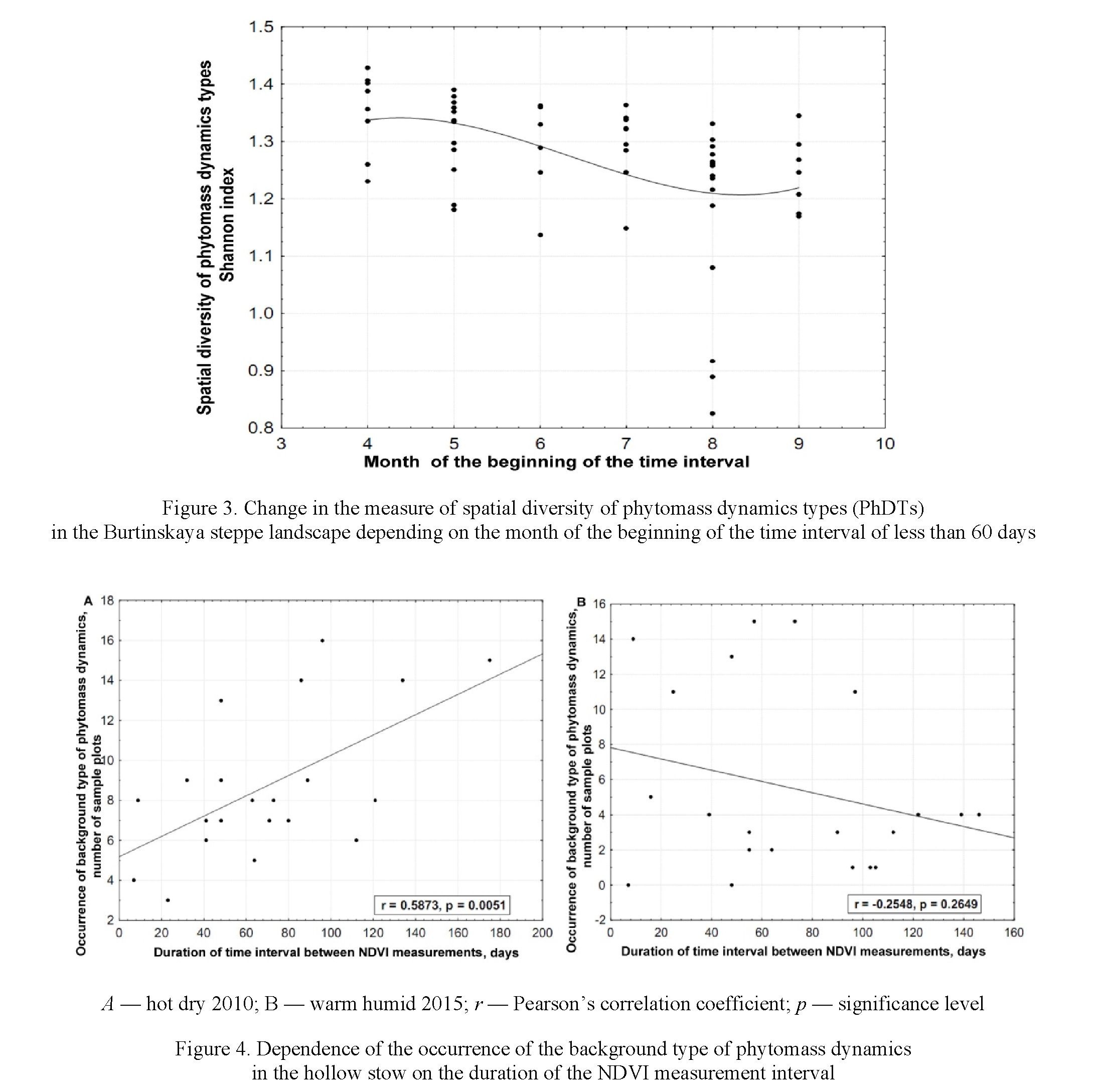
tors lasting 15–30 days. The breakdown of the integral phytoproductive functioning of the landscape into separate types at intervals of up to 60 days is most pronounced in the first half of the season (with the initial date of the interval in April and May), which can be seen from the values of the measure of the spatial diversity of PhDTs (Fig. 3). During the summer, the variety of functioning options decreases from June to August. However, at the end of the season (with the initial date of the interval in August), depending on the hydrothermal conditions, the spatial diversity of PhDTs may vary greatly from year to year. It was minimal in 2014, which was characterized by very dry weather in August and September. The area with the background PhDT 3 was the maximum. In September, the variety of options increases again.
For example, within transect 1 (“ridges and flat-bottom valleys”), the maximum diversity of dynamics types was usually observed at short time intervals (up to 15 days). The increase in the duration of the interval with the beginning in May-June is consistent with the increase in the uniformity of the PhDTs. In interfluves with zonal steppe communities, the consistency with the whole landscape was high at 4–5-month intervals. In other words, the difference between the phytomass of the beginning and end of the growing season coincided on all plots and corresponded to the modal increments characteristic of most of the landscape. In the interval of 30–60 days, the synchronous dominance of the background dynamics on the interfluves took place only at low average daily temperatures of less than 14 °C in autumn and spring. At the highest temperatures, dominance passes to PhDT 4 corresponding to a strong loss of phytomass in late summer. On transect 2 (“gully”), an increase in the occurrence of background dynamics with an increase in the duration of the interval was clearly manifested in dry years (Fig. 4, A). However, in wet years, sufficient soil moisture throughout the season maintained the phytomass at a level that differed greatly from the background steppe (Fig. 4, B).
Discussion
The study enabled us to identify phytocenotic features corresponding to the predominance of each type of phytomass dynamics and their changes during the growing season.
In hot dry years, the uniformity of the types of phytomass dynamics increases at a landscape scale. This is explained by the fact that numerous gullies and narrow ridges lose the originality of their mode of operation and obey the modal PhDT 3. In other words, the integrity of the unified response of the landscape [5] to the growth of moisture deficiency is enhanced. In cool, humid years, the functional integrity of the landscape decreased, and the diversity of types of dynamics increased. The area with reduced phytomass losses increased in the second half of summer relative to the background. Different landscape units (gullies, flatbottom valleys, flat interfluves, slopes) reacted differently to increased moisture; the integrity of the same type of response was lost.
The background phytomass dynamics (PhDT 3), covering the main part of the landscape, was usually most pronounced in most landscape units over a long interval (3–5 months), especially in hot dry years. For short periods (up to 1 month or 1–2 months) within the season, under the influence of short-term activation of local factors, deviations from the background dynamics often occur. Possible explanations involve an increase in soil stoniness, a sharp moisture deficit, a temporary excess of soil moisture after spring snowmelt or rains, and a short-term high position of groundwater in a gully.
In the gullies, which combine the features of steppe and meadow phytocenoses, during extreme drought, there was a sharp reduction in the mass of forbs. By this, they switch to the “steppe” mode of functioning. Consequently, in arid conditions, a shallowly incised gullies lose their inertia of functioning and, hence, originality as a separate landscape unit. The phytocenoses in convex well-drained landforms (ridges) are also subject to the integrity of the unified response at a landscape scale during dry periods. Flat and gently sloping interfluves, on the contrary, join the background dynamics in cool wet years, and function independently in dry years. Thus, the types of natural landscape units (flat interfluves, slopes, ridges, gullies) “join” the background dynamics of the landscape scale under different hydroclimatic conditions.
Strong deviations from the background dynamics outside the gullies can be induced by the local drivers lasting 15–30 days. Shorter intervals are apparently insufficient for the accumulation or disappearance of the required amount of moisture. The diversity of local dynamics factors is most pronounced in the spring. The reasons may be uneven heating and depletion of thawed soil moisture and different duration of the period after snowmelt in convex and concave landforms as well as at different slope aspects. The integrity of the unified response [5] is most clearly realized over the landscape over long intervals about 4–5 months. This means that contrasting types of landscape units (gullies, slopes, plateaus, ridges) increase or lose green and dead phytomass by approximately the same amount, corresponding to the background landscape response to the intraseasonal trend in moisture supply. We believe that this is a vivid confirmation of one of the most important theoretical provisions of landscape science about the consistency of the spatial and temporal scales of geographical processes. The process (in our case, a seasonal decrease in moisture supply, which is reflected in a decrease in phytomass), covering a large area (landscape as a whole), is fully realized only over long time intervals (in our case, 4–5 months). However, with the same duration of the interval (4–5 months), the increase in moisture (Selyaninov coefficient more than 0.4) causes an increase in the diversity of PhDTs, mainly due to an increase in the area covered by the PhDT 2 (partial preservation of phytomass in summer) and PhDT 4 (loss of phytomass in summer is greater than background). Thus, the integrity of the functioning of the low-mountain-steppe landscape is manifested in a rather narrow range of weather conditions corresponding to the hydrothermal norm of the steppe zone with the Selyaninov coefficient of the May-August period less than 0.4.
At short intervals (1–2 months), the functioning switches between a number of types, depending on belonging to one or another type of a landscape unit. The unified functioning at short time intervals is typical for periods characterized by an increase in stress factors of moisture and heat deficiency. During the growing season, such small deviations compensate each other. As a result, from the “start” to the “end” date of a long time interval, most of the landscape units change their phytomass in approximately the same way, which proves the integrity of the functioning of the landscape as a single geosystem.
Our study provided the opportunity to establish several ways of phytocenoses adaptation to different durations of strong local drivers. Some phytocenoses tend to maintain the structure of the phytocenosis during summer drought by changing the intensity of the biological cycle, more precisely — phytoproductive functioning. Others, on the contrary, change the structure (i.e. species composition) to preserve the phytomass and productivity characteristics, i.e. the volume of the substance involved from the soil into the phytomass. Finally, some phytocenoses have the ability to maintain both the structure and the nature of functioning. In terms of types of stability proposed by M.D. Grodzinsky [19] these ways are referred to as inertness, elasticity, and plasticity.
In the bottoms of the widest valleys with a large catchment area, a large phytomass is retained throughout the summer folowing its rapid increase in spring. Such dynamics is considered as a manifestation of inertness, that is the ability to maintain structure and functioning under conditions of strong external influence — a decrease in precipitation. In this case, this type of stability is ensured by the constancy of the action of a strong local factor, namely — excessive soil moisture despite a deficit of precipitation.
In the flat-bottom valleys and at the footslopes, inertness under the action of a strong external signal is uncharacteristic. The alternative mechanism of adaptation is to reduce the phytomass of dominant species without replacing species. In other words, self-regulation (sensu [20]) occurs. To reduce the negative effect of late summer drought stress, the consumption of deficient moisture is minimized, and phytocenosis reduces phytomass. With an increase in moisture supply, the previous mode of functioning is restored with intensive production of phytomass. This type of stability manifests itself also through the restoration of background dynamics after short-term deviations. In our case, such deviations under the influence of strong local factors last up to 1–2 months, but the dynamics for 4–5 months does not differ from the background in most tracts.
Finally, adaptation of the phytocenosis to the summer depletion of soil moisture can involve but the replacement of species to maintain phytomass. This is typical for petrophytic communities of stony tops and south-facing slopes, where the activity of Artemisia and Galatella species increases at the end of summer. Such a partial change in the structure is treated as a self-organization mechanism [20]. The landscape units demonstrate plasticity since they have the ability to switch to another state that maintains the previous intensity of functioning.
Conclusions
- Holistic phytoproductive functioning of the low-mountain-steppe landscape is most clearly manifested in dry periods, when phytocenoses of convex and concave landforms lose their specificity of functioning.
- Depending on the location, phytocenoses adapt to the late summer moisture deficit either by transitioning to another stable state of the structure while maintaining the intensity of functioning (selforganization), or by maintaining the structure while reducing the intensity of functioning (self-regulation).
- Short-term (up to 2 months) deviations of the phytomass dynamics from the background under the influence of strong local factors at longer intervals (4–5 months) are mutually compensated. The dynamics of hydrothermal conditions over the entire growing season manifests itself in a similar way in the territory of the landscape, which proves the connection between the spatial and temporal parameters of landscape organization.
Acknowledgements
The research was financially supported by the Russian Foundation for Basic Research (project 20–05– 00464).
References
- Isachenko, A.G. (2004). Teoriia i metodologiia geograficheskoi nauki [Theory and methodology of geographical science]. Moscow: Akademiia [in Russian].
- Forman, R.T.T. (2006). Land mosaics. Cambridge: Cambridge University Press.
- Puzachenko, Yu.G. (1986). Prostranstvenno-vremennaia ierarkhiia geosistem s pozitsii teorii kolebanii [Spatio-temporal hierarchy of geosystems from the position of the theory of oscillations]. Voprosy geografii — Issues in Geography, 127, 96–111 [in Russian].
- Shugart, H.H. (1999). Equilibrium versus non-equilibrium landscapes. Wiens, J.A. & Moss, M.R. (Eds.). Issues in Landscape Ecology. Snowmass Village. Colorado, USA, 18–21.
- Bokov, V.A. (1990). Prostranstvenno-vremennye osnovy geosistemnykh vzaimodeistvii [Spatio-temporal foundations of geosystem interactions]. Doctoral thesis. Moscow [in Russian].
- Delcourt, H.R., Delcourt, P.A., & Webb, T. (1983). Dynamic plant ecology: the spectrum of vegetation change in space and time. Quartenary science review, 1, 153–175.
- Titlianova, A.A., Bazilevich, N.I., Shmakova, E.I., Snytko, V.A., Dubynina, S.S., Magomedova, L.N., Nefed'eva, L.G., Se- menjuk, N.V., Tishkov, A.A., Ti Tran, Hakimzjanova, F.I., Shatohina, N.G., Kyrgys, Ch.O., & Sambuu, A.D. (2018). Biologiches- kaia produktivnost travianykh ekosistem. Geograficheskie zakonomernosti i ekologicheskie osobennosti [Biological productivity of grass ecosystems. Geographic patterns and ecological features]. Novosibirsk: Institut pochvovedeniia i agrokhimii Sibirskogo otdeleniia Rossiiskoi akademii nauk [in Russian].
- Solntsev, N.A. (1948). Prirodnyi landshaft i nekotorye ego obshchie zakonomernosti [The natural geographic landscape and some of its general rules]. Proceedings of the Second All-Union Geographical Congress, 1, 258–269 [in Russian].
- Dyakonov, K.N. (2007). Landscape studies in Moscow Lomonosov University: development of scientific domains and education. In: Dyakonov, K.N., Kasimov, N.S., Khoroshev, A.V., Kushlin, A.V. (Eds.). Landscape analysis for sustainable development. Theory and applications of landscape science in Russia. Moscow: Alex Publishers, 11–20.
- Mordkovich, V.G. (2014). Stepnye ekosistemy [Steppe ecosystems]. Novosibirsk: Geo [in Russian].
- Chibilev A.A. (2017). Stepnaia Evraziia: regionalnyi obzor prirodnogo raznoobraziia [Steppe Eurasia: a regional overview of natural diversity]. Moscow, Orenburg: Institute of steppe, RGO [in Russian].
- Eremeeva A.P. (2012). Prostranstvennye masshtaby proiavleniia faktorov differentsiatsii landshaftov Burtinskoi stepi (Orenburzh'e) [Spatial scales of manifestation of landscape differentiation factors in the Burtinskaya Steppe (Orenburg Region)]. Vestnik Moskovskogo universiteta, Seriia 5: Geografiia — Proceedings of Moscow University, Geography 5 series, 4, 48–53 [in Russian].
- Kalmykova, O.G. (2015). Kharakteristika nekotorykh stepnykh formatsii Burtinskoi stepi (Zapovednik «Orenburgskii») [Characteristics of some steppe formations of the «Burtinskaia steppe» (reserve «Orenburgsky»)]. Vestnik Orenburgskogo gosudar- stvennogo universiteta — Proceedings of Orenburg State University, 13(188), 138–140 [in Russian].
- Dusaeva, G.H., Kalmykova, O.G., & Dusaeva N.V. (2021). Effects of fire on production and destruction processes in steppe phytocenoses of Burtinskaya Steppe, Orenburg Nature Reserve. IOP Conference Series: Earth and Environmental Science: 9, 012031.
- Khoroshev, A.V. (2020). Prostranstvennaia struktura kak faktor stabilnosti bioproduktsionnogo funktsionirovaniia stepnykh geosistem (na primere Aituarskoi stepi, Yuzhnii Ural) [Spatial structure as a factor in the stability of the bioproductive functioning of steppe geosystems (on the example of the Aituar steppe, South Urals)]. Printsipy ekologii — Principles of ecology, 9 (3), 71–86 [in Russian].
- Khoroshev, A.V. (2021), Landshaftnye usloviia stabilnosti fitoproduktsionnogo funktsionirovaniia v Aituarskoi stepi (Yu- zhnii Ural) [Landscape conditions for the stability of phytoproduction functioning in the Aituar steppe (Southern Urals)]. Vestnik Moskovskogo universiteta, Seriia 5: Geografiia — Proceedings of Moscow University, Geography 5 series, 2, 82–91 [in Russian].
- Khoroshev, A.V. (2021). Dynamics of phytoproductive functioning of low-mountain steppe landscapes of the Southern Urals. IOP Conference Series: Earth and Environmental Science, 817, 012046.
- Khoroshev, A.V., Ashihmin, A.P., Kalmykova, O.G., & Dusaeva, G.H. (2021). Landshaftnye faktory stabilnosti dinamiki fitomassy v zapovednykh i pastbishchnykh nizkogorno-stepnykh landshaftakh Burtinskoi stepi (Yuzhnyi Ural) [Landscape factors of phytomass dynamics stability in reserved and grazed low-mountain-steppe landscapes of the Burtinskaia Steppe (Southern Urals)]. In: Dinamika i vzaimodiiestvie geosfer Zemli — Dynamics and Interactions of the Earth Geosystems. Vol III. Tomsk: Iz- datelstvoTomskogo CNTI, 85–88.
- Grodzinsky, M.D. (2014). Landshaftnaia ekologіia [Landscape Ecology]. Kiev: Znannia [in Ukrainian].
- Armand, A.D. (1988). Samoorganizatsiia i samoregulirovanie geograficheskikh system [Self-organization and selfregulation of geographical systems]. Moscow: Nauka [in Russian].