One of the basic conditions of the achievement is exact and clear information.
But the most important thing is the way one can use this information. The methods of working with information are developed every day, and the documents, tables, graphics, diagrams, drawings and pictures can be seen at computer screen. Using computers we collect material, change them, print and analyze them. The influence of the computer is so great that it even makes geographic maps.
Nowadays information technologies (IT) penetrated into all spheres of scientific research centers and experimental sites — beginning from schools to state political institutions.
In geo-sciences geo-information systems (GIS) were created on the basis of IT. GIS is specific information and programming area which collects, changes, forms and distributes the material that was systemized in that space.
One of the main functions of GIS is to compile and use computer (electronic) maps, atlases and other cartography works.
The end of the XX-th century is characterized by implementation and wide use of computerization and automatization. At this time cartography became one of main consumers and managers of information about the interrelationship and interaction between the nature and society [1].
Modern computer technologies in practice proved their exclusiveness in the way they process the material. The combination of computer technologies (especially material processing and analyzing) and traditional cartography gave new opportunities to this field of science and lead to the creation of GIS [2].
GIS — is a computer system which enables showing information on the electronic map. The maps created by GIS can be confidently called maps of new generation. In GIS maps not only geographical but as well as statistic, demographical, technical and some other information can be applied and used in analytical way. GIS can use usual paper maps, and possess methods that can be used to clarify latent links and tendencies [3].
The first GIS was created to investigate natural resources in Canada, USA and Sweden in 1960-s. Canadian GIS originated from the research of R.Tomlinson (1963–1971) that was related to bibliographical aspect as well as proper use of natural and environmental resources. And in Sweden the land cadastre of T.Germansen, O.Salomonsson (1976) initiated establishing of GIS. Various societies and scientific centers participated in creation of GIS. GIS was created as multifunctional information system. Canadian GGIS was generally recognized as the best information system. The results of the work done in 1976 were concluded in R.Tomlinson’s monograph.
At the beginning of 1970s the development of GIS started in many fields of Geo sciences. Thus in 1976 in Geological service in the USA more than 50 automatic systems were created for compiling and processing of cartographic information. At that period first information systems (IS) have begun their development in former Soviet Union [4].
Since 1970s GIS has being used not only in military sphere but in educational system as well. In 1980– 1990s due to emergence of personal computers and their wide use, GIS gradually satisfied the demands of the world market and began its spreading within Russia and KSSR (Kazakh Soviet Socialist Republic). The GIS products’ sales rates are increasing year after year, besides GIS services are developing up to 20–30 % annually and nowadays its sales rate makes $500 000000000.
At present starting from the first time of GIS emergence there are some debates related to the GIS term. Come scientists call it information system and consider it to deal with collection, accumulation, processing, representation and distribution of information on space coordinates. And some scientists take into consideration the structure of programs and call programmed spaces with this term.
For instance, MapInfo, WinGis and so on are considered to show the relationship between data base and electronic map.
If in foreign countries GIS was created in state organizations (in some structural departments such as geological, military-topographic or some others) or in some local government bodies, in former Soviet Union the data collection was put on special departments.
At Pacific ocean region’s geographic institute of the Science Academy in former KSSR the process on GIS establishment had started, and assistance of the chair of cartography and informatization of MSU (Moscow State University) was required in order to establish and develop automatization of cartography in other educational centers.
In Russia and CIS countries the profound research had started in 1980s.
The Russian GIS is based on works of such researches as S.N.Serbeniyuk (1989), A.M.Trofimov (1989), A.V.Koshkariyov, V.S.Tikunov (1991), V.I.Semenov, O.I.Solntsev, V.I.Tikunov (1991).
The Georgian GIS is related to the works of Tbilissi university professor N.L.Beruchashvilly (1986). Estonian GIS is well-known with P.H.Karing’s (1980) works. And in Kazakhstan the first foundation of GIS started and is connected with the research work of A.A.Tursynov, G.V.Geldieva on Aral sea problem and as well with the names of such researches as E.A.Zakarin, L.F.Spivak [5].
At recent time there are new tendencies in development process of society in the whole world and in Kazakhstan. These tendencies are closely related to large scale of information technologies and information services as well as all spheres of human activity.
In West Kazakhstan using GIS technologies methods are created for pollution level evaluation, monitoring and controlling. On the basis of new geo-information system the pollution rates were determined and owing to it the qualitative evaluation of air-water pollution was determined in West Kazakhstan’s oil-gas deposit regions. But these systematization required use of landscape maps, and their compiling by traditional methods is laborand money-consuming process [6].
In Kazakhstan GIS technologies are developing. Social and marketing research agency BRIF is in Kazakhstan one of the first private companies. It was founded in 1991 to study the social and political and economic development in independent Kazakhstan [7]. BRIF is branch of Central Asian geo-information system agency, and was being engaged during past 6 years in compiling and processing of electronic maps. Nowadays in MapInfo format several maps were created, and among them the map of Kazakhstan, the map of large cities, these are: Astana, Almaty, Karagandy, Shymkent, Oskemen, Semey, Pavlodar, Taraz.
The map of Kazakhstan consists of following information layers: oblasts’ and districts’ border lines, settlements, hydrographical nets, hypsography, rail road net, automobile-road net, agro-climate zones, pipelines, electric supply nets, mines, information-layers on ecology and medicine and health. The maps of the cities consist of following layers: streets, street crossings numbers, roads, hydrograph, green plantations, social objects, polling places, trade places, special information-layers on ecology and medicine, health.
The attachment of GIS to BRIF is based on the fact that it is trade and social marketing. They compile topical (thematic) maps, make selected maps of settlements and separate cities, and they can show and define regularities between phenomena that cannot be shown in simple schemes.
The agency’s list of objectives for GIS:
- distances, to measure of square;
- to paint convenient route;
- to decide logistical objectives;
- to choose new and old point by signs combinations;
- to take into account transport’s tendency;
- to make a map density of people among region and town;
- extension ability of information base and e.t.c. [7].
With the help of GIS we can use different program versions such as MapInfo, Auto Deck, Arc GIS to make earth relief models. For example, the new third-volume state atlas of Republic of Kazakhstan was made by version Arc GIS 9.1.
The next way of Kazakhstan map-making — the first National Atlas of Independent Republic of Kazakhstan. With the beginning the Ministry of protecting environment «Ecological Atlas» was made by the Institution of Geography. In our country like these group of maps made in 1982–1983.
There are following foot-notes in the town-information system and interactive maps:
- map.east.kz — GIS of Ust-kamenogorsk;
- temirinfo.kz — GIS of Temirtau;
- temirinfo.kz in this cite there is new version of interactive map of Temirtau town and Aktau settlement.
- kn.kz in this cite there are maps of Karaganda and Astana.
- mycity.kz in this cite we may see navigation-information system «Karaganda — is my city» and the new project My City. kz.
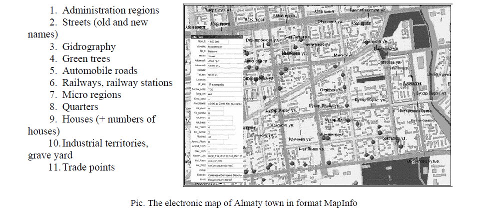
Pic. The electronic map of Almaty town in format MapInfo
Nowadays, there are thousands GIS in developed countries. We may use them in economic, policy, ecology, to protecting and managing environment, earth cadastre, science, education system. In Kazakhstan these systems are developing.
List of literature
- Берлянт А.М. Картография: Учеб. для вузов. — М.: Аспект Пресс, 2002. — 336 с.
- Абакумов И.Е. Применение ГИС технологий для реализации картографических систем // Из материалов VIII Межрегион. науч. студен. конф. ТФ МЭСИ «Экономико-правовые и социальные проблемы адаптации региона к условиям информационного общества». — Тверь,
- Қазақстан картографиясын дамытудың перспективасы article. — http://qazaqia.blogspot.com
- geocenter.kz
- Kerimbay N. Geoinformation bases. — Almaty: Kazakh universitet, 2006. — Р.
- dataplus.ru
- brif.kz
- Kazakh-russion, russion-kazakh terminologation dictionary: Informatics and subtract technology / Жалпы ред. басқар. проф. A. — Almaty: Rauan, 1999. — 304 p.
- Багров Лео. История картографии. — М.: Центрполиграф, 2004. — 320 с.