In the article geographic factors of influence on the arid relief of Kazakhstan were considered. Changing of pluvial and xerothermic ages is shown. Conformity of xerothermic epoch with tendencies of modern reliefforming is defined. Arid type of climate of Kazakhstan contributes to the lack of local flowing waters. It is known that, climatic, hydrographic and geomorphologic factors influence on the distribution and accumulation of groundwaters.
Arid character of climate causes the complete absence in the territory of deserts of Kazakhstan local watercourses. Large transit rivers — Ural, Syrdarya, Shu, Sarysu, Ili and others — start outside of the desert zone. They belong to a closed Aral-Caspian and Balkhash-Alakol basins. Except the Aral Sea, lakes Balkhash, Alakol, Sasykkol, Aris within the desert zone are numerous drainage basins occupied by salt marshes, brackish and saline drying up lakes. South-western slope of the Subural plateau dissected on the watershed by river valleys, which currently do not fall anywhere. Their origins lie in the Cretaceous ridges of UnderUral, and Emba only reached its source to the spurs of Mugodzhars. Middle parts of all these rivers cross the area Predsyrt escarpment Subural plateau. The lower reaches of the rivers are lost in the estuaries of the Caspian, gradually lose their valley and the flow through the flat and wide depressions with a slight slope. In the spring trough filled with water, formed spills. The upper reaches of the Ural River are Uraltau spurs at the foot Nazhimtau at an altitude of 637 meters above sea level. In territory of Kazakhstan lower, estuaries, part of the river is located. Here Ural stands out Caspian littoral landscapes. A characteristic feature is wide (from 2–3 to 8–10 km) floodplain, bordered by narrow (1–3 km) strips the lower floodplain terraces, which rises to 8–11 meters above the mean water level. The high level of water in the spring and early summer, the rapid flow leads to an erosion of shores. This contributes to changes in the riverbed, the formation of new branches, backwaters, oxbows. In places where the eroded bedrock bank, steep cliffs are formed. The entire floodplain is characterized by a strong ruggedness. On the way to the Caspian Sea crosses their ancient Ural delta formed during the retreat of the Hvalynskoe sea and left their mark on the character of the modern river valley. Floodplain in the lower reaches of the Urals is divided into three parts: the riverbed, central and high. Riverbed floodplain rises above low-water at 1,5–8 m; central — on 3,8–8,5 and high — 6–10 meters. The average level of flood waters in the floodplain of 5–6 m, to the mouth it is reduced to 1,3 m. In 1942, near the village of Kalmikovo had the highest flood: the level of river rose to 11 m., waters flooded floodplain terraces and depressions entered the interfluvial space. Delta of Ural begins over 170 km from the present mouth of the river, the width of which is gradually increased to the south from 10–15 to 60 km. To the mountains of Atyrau delta has the form like a regular river valley. From the river bed a small branches Narynka and Baksai separated, filled with water in the Urals only in wet years. Along the river as well as in the lower reaches should riverine floodplain width from 0,5 to 3 km, and the height above low-water level of the river is gradually decreasing (from 6 m to 2 m). The lower delta of the Ural starts back from Atyrau after branching left branch Peretaska, after which followed Buharka and Yaitsky. Mainstream of the Ural flows into Golden branch, which flows through the middle of the spit, extended far into the sea. The whole system of branches and ducts functions in flood. In the summer time runoff of the Ural to the Caspian Sea is carried out only in two branches. Ural delta is characterized by unstable equation regime. On the water surface windtide phenomena are observed. With southerly winds surge waves interfere to the normal flow of the river. During storm events from the water appear islands covered with shell rock, shallow waters of the sea dry off [1].
Emba river begins from the western slopes of Mugodzhars. Valley of the river flows through ridges of Cretaceous age — Aktolagaj, Shirkal, Iman-Kara, Coy-Kara and, gradually losing its waters, crosses semideserts and deserts of the Caspian depression. In recent decades, Emba did not deliver its water to the Caspian sea. The length of the river s 712 km, the basin area is 40,4 km2. It is snow-fed stream. The main flow (95 %) is in April-May. Water in the river is heavily mineralized and changes considerably throughout the year. In the summer, in the upper reaches mineralization corresponds to 800 mg/l in the lower reaches by 4–6 times more. The upper reaches of the Emba represent a narrow valley, the channel consists of a chain of deep-water reaches. Below the mouth of Temir valley widens, the channel begins to meander. The shores here are steep and almost treeless. In the delta of the Emba saltwort vegetation grows. Low wet meadows occupied by impenetrable thickets of reed and cattail. On elevated areas wheatgrass, azhrek, kermek lawns are spread. Landplots of the delta, coming out of the flood zone, overgrown with white wormwood, Anabasis salsa. One of the tributaries of the river Emba was Sagyz. At the present time it is drying river. The length is 511 km, the basin area of 19,4 thousand km2. On the right bank is located sandy area Kyzyl Kum-Sagyz. In the lower reaches of Sagyz dominated meadows of thistle, wormwood. On the bright solonetzic-saline soils vegetation is represented by cheegrass. Lowerings are occupied by azhrek-saltwort association. Near the village Sagyz riverbed losts among the salt marshes Tenteksor. There is a high degree of mineralization at flood 700–800 mg/l, at mean water — up to 20 thousand mg/l. Uil river has a length of 800 km. The catchment area of 31.5 thousand km2. It is snow-fed stream. Sandy massifs Barkin, Taisoigan and Biyryuk are framed riverbed on its way to the Caspian depression, where the river divides into several branches. Valley of the river Sarysu in the upper reaches has a width of about 20 km and is made from the surface of red clay. Extended areas in the upper reaches recognized by some researchers (Z.A.Svarichevskaya, 1965) as areas of insignificant local deflections, probably at one time filled by lakes. In the Quaternary period the real erosional valley has arose, in which a clearly visible floodplain and the first above the floodplain terrace with a height of 5–6 m, folded by sandy loam, gravel and pebbles.
According to its morphological features Mointy river valley is divided into upper and lower parts. On the upper part the width of the valley is 7–10 km. Its bottom directly from the surface is composed of red deposits, which lying at the base of kaolinized sands with inclusions of pebbles, sometimes cemented by sandstone-conglomerate. Capacity is 6 m, age is Upper-Oligocene. Red clay are cut by comparatively narrow young valley Mointy of quaternary age and older bottom rises above the modern channel of in the form of terrace, a height of 12–15 m. Below the station Gingil bifurcation of the valley notes, and its left branch Mynshukur merges with the mouth of the valley Zhamshi. The right branch, or the main valley of Mointy, below the station Gingil narrows and it has no red clays. In it four terraces can be traced. The first and second terraces have quaternary age, and the third and fourth (height of 2 and 10 m, respectively) are composed of pebbles of the Upper Oligocene. Their exposure is associated with the rise of the ancient valley bottom. The greatest development fourth terrace has received on the left bank of Mointy at the mouth, where it is directly comes to Balkhash. Valley of the river Tokrau and inflow Cusack, width of 10–30 km, are made of Miocene variegated clays. In the middle part extensive bottoms are cut by Quaternary valleys with a dry riverbed. In the upper reaches of the river Tokrau notes well elaborated floodplain and four alluvial terraces. Riverbed, made of pebbles, can be traced to the lower reaches of the valley and lost at the end of its extensive delta, which was strongly dispelled in xerothermic era and turned into a hilly sands height of 5–7 m. Near the lake Balkhash delta in the Upper-Quaternary period exposed to flooding and then salinization. Within the deserts of southern Kazakhstan Syrdarya river flows, formed by the confluence of Naryn and Kara-Darya rivers in the Ferghana valley. The length of the Kazakh part of Syrdarya corresponds to 1400 km, the basin area of 240 thousand km2, water consumption — 703 m3/s, the drain — 22170 mln. m3. During the flood period runoff of the Syrdarya increases by several times. River waters are bottled at 5–8 km wide. Within the Fergana basin Syrdarya has a wide floodplain (3–4 km) and two terraces above the floodplain. The second terrace, 8–10 m high, occupies most of the bottom of the hollow, gradually merging with the alluvial fans of rivers. Currently riverbed changed in the mouth part and Syrdarya flows into the Small Sea. At Big Sea runs only Amudarya, the average annual runoff near the village Kyzylzhar, which is of 120 km from the mouth, is 5,7 km3 [2].
Waters of mountain rivers of Tian Shan weakly mineralized and belongs to hydrocarbonate class. In the flood period their mineralization does not exceed 150–200 mg/l, and in the origins — 30–50 mg/l. During the flood period goes up to 95 % of the annual flow of suspended sediment, in low water period the turbidity is minimal. The turbidity of Syrdarya reaches 1200 g/m3. About precipitation amount, carried by Syrdarya, can be judged by the rapid growth of its delta. From 1847 to 1900 Syrdarya has put forward its delta of 5,1 km. During these same years, the delta area increased by 35,7 km2. One of the typical features of a river system in the deserts is the presence of a large number of dry riverbeds. Many of them are in Syrdarya basin. During the flood period waters of the river flowing at a speed of 5–6 km/h, blurring the low banks, composed of loams. The river meanders, overgrown with new branches and tributaries. The oldest waterless tributaries of Syrdarya are Jana-Darya and Kuvan-Darya. Only in some wet years Syrdarya waters penetrate into the mainstream of Jana-Darya, feeding by invigorating moisture the parched lands. The Ili River is less abounding than Syrdarya. Within Kazakhstan its length is 815 km, the basin area of 68.4 thousand km2., water consumption 464 m3/s, the drain — 14616 mln. m3. Turbidity of the water of the river is 650 g/m3, to the downstream increases to 800–1000 g/m3. The main source of the Ili River — the river Tektes — begins near the mountain rivers of snow and glaciers of the northern slope of Terskey Alatau ridge and Khan Tengri mountains. Flows first from the west to the east along the wide longitudinal valley between the chains of Tian Shan and goes beyond China. Here the river breaks through the penetrating gorge through the ridge Shikilik and enters to the eastern part of the Ili graben. Merged with the river Kunges and turning to the west, the river enters again into the territory of Kazakhstan under the name Ili. On this segment river flow is smoothly, the width of the riverbed if 150–200 m, depth on reaches — 6m. In the western part of the graben river Ili receives a number of significant tributaries. From the side of Dzungarian Alatau right tributaries: the river Khorgos, Usek, Borohudzir; left tributaries — Sharyn, Shelek, Kaskelen. The Ili river is divided into three sections, differ greatly from each other: the first section in the Ili Basin, the second — when crossing the plateau Karoy by narrow penetrating Kapchagai gorge (depth is 200 m., width — 80–300 m), the third — in the Balkhash basin, where there is a vast delta. The Ili River has two floodplain terraces and flood plain. In the gorge notes one terrace above the floodplain and floodplain. The third section of Ili is a delta, leaning against the sandy massifs, recycled by eolian processes. Sandy massifs — Bestaz, Saryesik-Atyrau, Taukum — are characterized by a pronounced ridge-structure of the north-west direction. Ridges are relict, they cross the river, its delta, and in places destroyed by the wind. Delta of the Ili river has a complex structure and consists of three leaning against each other deltas, different in composition and structure. The relief of the deltas complicated by eolian formations. The most ancient is Akdalinsk delta, which is preserved only in the upper part of the river. It is raised in the form of a cone and is dotted with the remains of ancient channels. Bakanas delta is raised in the central part to the branching of riverbed on branches Shet, Orta and Naryn-Bakanas. There are marked single high dunes and ridges of ancient aeolian relief. Their height corresponds to the level of sand ridges Taukum and Saryesik-Atyrau. There are also young aeolian formations with height up to 5 m. Bakanas delta is cut by the system of dry river beds, located above the modern riverbeds of Ili. Riverbedsbakanas are deeply embedded in the surface of the delta. Their coastal cliffs often reach 5 m, what indicates the intense erosion. Probably deepening bakanas occurred during temporary of the regression of Balkhash. This is indicated by the presence of continuations bakanas at the bottom of the modern Balkhash. Relief of the deltas characterized by sandy aeolian ridges of north-west direction, interspersed with water bodies, reed beds and marshes. Modern delta located between channels Zhideli and Topar, between which extends the mainstream of Ili, length of 4 km. On the right bank of the river there are dry riverbeds. According to B.K.Stegmann, their drainage happened because the Ili River brings now less water and does not fill all the riverbeds in the delta. Sharp shallowing of mainstream, abounding sandbanks, is evidence of this. In the lower reaches of the Ili and its ducts are encountered sickle-shaped lakes and chain of lakes, which are the remnants of ancient riverbeds. Mostly they are used by modern ducts causing their harsh lake-like expansion.
Shu River in the mountains on different parts has different structure. Above the Issyk-Kul depression it flows through Kochkor hollow, then crosses the Upland of Ortho-Tokoy tract and goes out into Issyk-Kul basin, forming a vast delta. Within the hollow, reaching the low-lying plain of the ancient lake, it turns to the west, and cuts into the Neogene lacustrine terraces of Kapchagai tract, then crosses the Kyrgyz ridge by rocky gorge Boam. Upon leaving a Shu hollow river Shu newly formed cones. Valley is widened, the fall of the river decreases, the channel splits into branches and wanders over the floodplain. On the upper and lower parts of the gorge Boam terraces are different in their structure. On the lower part of the river Shu observed eight terraces above the floodplain, combined in three complexes. The upper complex consists of 8 (75 m), 7 (60–40 m) and 6 (30m) terraces; age is Mid-Quaternary. Middle complex formed 5 (20–25 m), 4 (17–19 m) and 3 (12–15 m) terraces; age is Upper-Quaternary. Lower complex consists of 2 (7–8 m) and 1 (3 m) terraces, of the high floodplain (0,5–1m) and low floodplain (0.5 m); age is modern. Shu river until recently belonged to the Syrdarya basin, and now it ends in salt lake Akzhaykyn. In territory of Kazakhstan there are more than 48 thousand By the number small lakes constitute 94 %, and by the area — 10 %; large lakes are about 3 thousand, and lakes with the area of more than 100 km2are — 22. In arid zones are many lakes, especially in floodplains and deltas drainless areas of rivers which are lost in the sands. Only in the Ili delta they are almost 11 thousand, many lakes also are in the lower reaches of Syrdarya, Shu, Sarysu. The Caspian Sea is the largest salty closed lake of the world, located at around 28 meters below sea level. Within the Kazakhstan length of the coastline is 2,340 km. Maximum water depth is 1025 m, average is 180 m, the volume of water 78 thousand km3. In the meridional direction Caspian Sea stretches for 1200 km, stretched in width — from 200 to 500 km. The total area of the basin is 3.5 million km2. The average salinity of the water is 12–13 ‰. Large bays are Mangistau, Kazakh. On the east coast of the sea there are no permanent streams (Fig. 1).
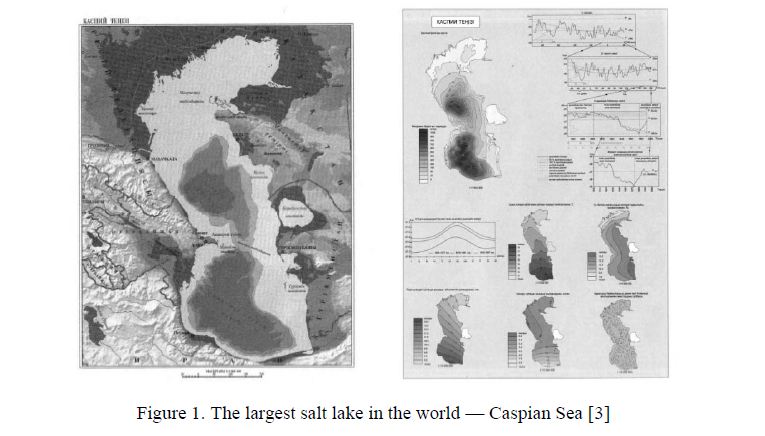
Figure 1. The largest salt lake in the world — Caspian Sea [3]
The northern shores are low, shores of the peninsula Mangyshlak are abrasion. In a natural way Caspian Sea is divided into three parts — north, very shallow water (4–10 m), average with depths up to 700 m, south with the depths of more than 1000 m. Middle and Southern Caspian separated by shallow water at the latitude of the Apsheron Peninsula. Three parts are different in size and volume of water. Northern Caspian occupies an area of 91,942 km2, the volume of water is 397 km3. Relief of the bottom is slightly undulating accumulative plain with the banks and islands. Sediments of Volga and Ural rivers form a plurality of shoals and banks that are a danger to navigation of seagoing vessels. There is a shallow (up to 8 m) extensive depression between the delta of Ural river and the peninsula Buzachi, which is called Ural Borozdina. On the east coast Peninsula Buzachi, sor Kaidak, Dead Kultuk are located. Bottom filled by sediments of the rivers Volga and Ural. Middle Caspian occupies an area of 140 thousand km2, the volume of water is 26,439 km3. The maximum depth is 788 m, average is 192 m. In the bottom relief clearly distinguished shelf, continental slope and the bottom of the depression. The shelf of eastern shore is wide with the relics of ancient river valleys. Shores are precipitous, steep. South Caspian is the deepest and seismically active moving part of the Caspian Sea. Total area is 148,640 km2. The volume of water is 51,245 km3. Maximum depth is 1025 m, average is 345 m. The bottom relief is complex. Shelf, continental slope, deep depressions and ridges are distinguished. The width of the eastern part of the shelf is 130 km, of the western coast is 43 km [4]. Surface currents in the Middle and Southern Caspian form a cyclonic circulation. In the North Caspian the regime of currents determined by river runoff and winds.
The entire thickness of waters of Caspian sea is well mixed. In the upper layer wind mixing is developed, deeper than 20–30 m — convection. In the development of the Caspian Sea the stages of falling water levels and stages of uplift are marked. At present, the Caspian Sea is experiencing a stage of raising the water level. Sea area expanded to 70 km, flooded 0,5 million ha. of grasslands and pastures, more than 100 oil wells.
The Aral Sea is the next big salt lake-sea of arid zone of Kazakhstan. On the map of 1942 the surface of the Aral Lake-Sea was a 64113 km2. Compared with the 1960 the level of the Aral Sea has sharply fallen, and it must be assumed that its area is now greatly reduced. In the surface waters of the Aral Sea is observed circular flow in a clockwise direction due to strong north-easterly winds (Berg, 1908). On the Aral Sea often observed seiches, due to differences in atmospheric pressure in different parts of the sea. The average height of seiches matched the mark of 24 cm. There have been phenomena of wind tides and ebbs in the lowland areas of the coasts. According to morphological structure water area of Aral Sea is divided into two parts — the Big and Small Sea. Small Sea and the eastern part of the Big Sea — shallow water, their depth does not exceed 10–20 m. The maximum depths (50–60 m) are confined to a narrow trough in the western part of the sea under the high cliff of the eastern escarpment of Ustyurt. The average temperature of the air above the sea surface in the summer time is 24–260 in winter 7–130 below zero. The average annual precipitation is 100–140 mm. In 1959 V.N.Kupetsky noted the freezing of the Aral Sea in all its parts.
The northern part of the sea freezes around the second half of November, and southern — for 15–20 days later. By the end of January, everywhere the landfast ice is formed, gradually widening towards the open sea. Due to the fact that over the sea in winter strong north-easterly winds are dominated, the fast ice constantly cracked and brought to the southwest, leaving a wide flaw ice-hole, where freezing occurs again. In the southern part of the sea ice massif is located, but not open water, as previously assumed. The level of the Aral Sea is exposed to significant changes, and in periods of reducing of the sea water is differed by twice salinity. The results of researches of N.G.Brodskaya (1952) indicate the presence of gypsiferous horizon with forms of mollusk shells Cardium edule under the 25–30 cm layer of silt at a depth of 10–16 m. According to N.G.Brodskaya, during the formation of this horizon salinity of the water of the Aral Sea was very high, and the level of 10–15 m was below the present [5]. Since 1961 began lowering of the level of the Aral Sea, due to the increase of irreversible withdrawal of water from rivers Amudarya and Syrdarya for agriculture. By 1987, the island Kokaral turned into a peninsula.
Syrdarya changed its course in the mouth parts and began to fall into the Small Sea. At present, to Big sea Amu Darya flows only. Syrdarya river in some years does not bring its waters to the sea. As a result of the reduction of inflows the level of Aral Sea by 1989 decreased by more than 14 m. The sea has lost about 25 thousand km2 of its water area, salinity increased threefold. According to the forecasts of Kazakh specialists to maintain of the level of water in the Big Sea is necessary water flow 25 km3 per year. Otherwise, the sea is divided into two parts — West, an area of 6 thousand km2 and East, an area of 16 thousand km2. Balkhash-Alakol group of lakes has a complex history of the evolution to the present time is the subject of debates and discussions. From the viewpoint of L.S.Berg (1904), Z.A.Svarichevskaya (1952) Balkhash lake is young, the character of the shores is ingressive. According to researches of B.F.Meffert (1912), M.P.Rusakov (1933), K.V.Kurdyukov (1952), the character of the shores is regression. Researches of Z.A.Svarichevskaya revealed: gravel terraces of Balkhash Lake is the fourth Upper-Oligocene terrace of the Mointy valley; coastal zone of Balkhash is characterized by the youth, shore is bay-like, ingressive, sometimes faulted (Fig. 2).
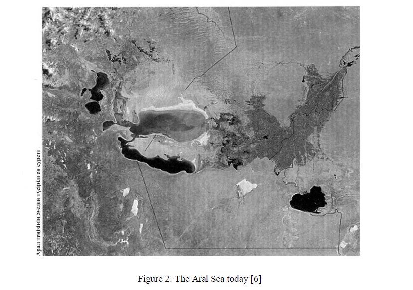
Figure 2. The Aral Sea today [6]
Forms of the shores of the Balkhash determined by dismemberment of land, flooded by lake. Saryshagan Bay is located on the site of the flooded mouth of the river Mointy. The absence of deep jutting bay at the mouth of Mynshukur and Zhamshi explained by powerful accumulation of alluvium in the valleys, which compensated the flooding of the river mouth. In the north-western part of the Saryshagan bay flooded rocky granite hills caused a kind of island relief, similar to skerry coast of Finland. At times, the lake fills sinking beneath its level denudation plain, and in some places plain interrupted by a sharp ledge, and the shore carries the traces of abrasion. However, the steepness of shores has a tectonic origin. This is evidenced by the ancient lake sediments at the foot of Targyl at a height of 9–12 m, a distinct straightness of western shores of the lake, as well as limiting shores of the bay Kashkanteniz by young faults and high altitude of beach ridges (up to 20 m). Along the coast stretches a narrow strip of beach and beach ridges, which are well developed and have a significant width and height (3–4 m). Occasionally there is an ancient shaft of Upper Quaternary age. It is very wide, overgrown with vegetation. At the mouth part of the valleys are encountered only modern shafts. They have a small width and height.
On the coast, at the mouth of the river Zhamshi and on the south shore of Balkhash is observed Aral type of shore, characterized by flooding hillocky desert aeolian relief. Flooding occurred in the UpperQuaternary era of water encroachment. Now the shore of the lake receded, and the ancient shoreline of the Aral type characterizes the sinuous edge of marsh plains. Fluctuations in the level of Lake Balkhash occurred and are occurring constantly. It periodically increases and decreases in size of area. The lowest level in the lake reached the end of the 40-s. Since 1952 began a sharp uplift, which lasted until 1962, and then again there has been a decline. The decline of the lake level from 1990 to 1993 corresponded to the level of 32 cm, from 1993 to 1995 there has been a rise in the level up to 28 cm. Since the end of 1995 to 1998 the lake level began to decrease and reached 21 cm. Short-period rhythms occur in the context of interdecadal level fluctuations of Balkhash lake (45–60 years). In 1941, Z.A.Svarichevskaya established a lake genesis of the vast plain to the north of Alakol. High altitude of the lake plains over the Alakol, which is observed at the periphery of the depression (in the north to 100 m), the presence of high terraces on the island Kiskene-Araltobe (up to 67 m) gave the reason to assume the existence in Quaternary period of lake basin, the height the level, which exceeds the current more than 100 m. However, further studies have shown the influence of tectonic movements on the modern high position of the lake formations. Lacustrine plains were involved in raising, spreading to the south of Tarbagatai and west of Barlyk. Alakol depression has a complex structure of the foundation, characterized by the presence of sharp ledges associated with young faults. This ledge at the bottom of the depression passes in a northwesterly direction. Shores of Alakol are characterized by high mobility. On the east coast continued uplift of the lake plains involves modern beach ridge, raised already at 2,5 m and intensely washed away by lake waters. In the north and south directions it descends and forms the beach and spits. Among the plains of Northern Alakol and South Balkhash raised islands of the overgrown aeolian sands. On Alakol they are sands Biykum, Barmakkum; in Balkhash — sands Bestaz, Saryesik-Atyrau, that have arisen due to re-winnowing of more ancient lake sands. On the lakes Alakol and Uyaly also notes fluctuation of the water level, and the lake Kily arose again on the site of solonchak. With elevated levels of lakes connected the reducing of the size of spits on the Alakol, flooding the ruins of buildings on Uyaly. Researches of the lakes of Balkhash-Alakol system show that there was a lower level of Lake Alakol. This is evidenced by flooded stumps and roots of trees at a depth of 3–5 m in the south-eastern part of the lake [7].
Groundwaters of arid zone of Kazakhstan formed by filtering of water of transit rivers and groundwater runoff from the surrounding mountain ranges. Dominated stratal waters associated with weakly dislocated sedimentary rocks of different ages. Under the Paleozoic and more ancient rocks at a depth of one hundred meters or more overlie fissure waters. The outcrops of groundwaters through cracks found in lowlands of Kazakh Uplands, in the mountains of Karatau on Mangyshlak, at the foot of the Chu-Ili mountains. Identified basins of fresh and slightly saline artesian waters occur at a depth of 100–400 to 500–800 m [3, 6, 8]. Fresh and slightly saline groundwaters with mineralization of 0,2–3 g/l developed in the eastern part of the Caspian depression, Northern Aral region, Mangistau plateau, in the basins of Syrdarya, Shu, Sarysu, Ili. Brine groundwaters with mineralization of 50–400 g/l are widespread in the aquifers of the Caspian depression, Shu-Sarysu depression, on the most part of Mangistau and Ustyurt. Significant resources of groundwaters are formed in sandy massifs of Moyynkum — 28 m3/s, on the left bank of Syrdarya — 13 m3/s, in the sands of Taukum and Saryesik-Atyrau — 26 m3/s. Formation of groundwaters within the basin occurs rapidly in some parts of the river valleys. For example, in the valley of Syrdarya for the filtration in friable alluvial deposits takes up to 13 m3/s, in the valley of Ili — up to 37 m3/s, in the valley of Shu — up to 7,9 m3/s. In the Caspian and Turan lowlands occurrence depth of the groundwaters ranges from 3–5 to 20–30 m, sometimes — up to 100 m. The chemical composition and reserves of groundwaters depends on local conditions and salinity of the surrounding rocks. In the Caspian solonchak deserts they are salted, and in ancient alluvial plains of the deserts of Kazakh Uplands — mostly fresh. On the large areas of clay and sand-clay plains groundwaters runoff is carried out in a deep pressure confined aquifer, occur at greater depths. Such areas include the western part of Kyzylkum, the western part of the plateau Betpakdala, clay plain in the lower reaches of the river Shu. On the spaces between the Caspian and Aral seas, in the valleys, which characterized by the aridity of the climate, natural conditions are less favorable for the formation of groundwater flow. Feeding has a focal character and occurs mainly in low areas due to the infiltration of winter-spring precipitation. The overall decline in the level of groundwaters and artesian waters in the Aral Sea basin is observed from the 60-s of the 20th century, occurs as a result not only of shallowing of the sea, but also the opening of aquifers by numerous self-flowing springs.
Droughts had a major impact, often repeated in those years; decrease of river flow, as a result of human activities. To studying and searching for groundwaters of arid zone of Kazakhstan a great importance was always attached, because surface waters are limited and unevenly distributed across the state, and groundwaters are the main source of water supply for many regions. Significant reserves of fresh water found in carbonate structures, ancient and modern valleys, sandy massifs, granitoids and metamorphic rocks. Along with the geological, climatic, hydrological conditions on the formation of genetic types of groundwaters of arid zone, their distribution and accumulation influenced also geomorphological factors.
References
- Chibilev A.A. The road to the Caspian Sea, Alma-Ata: Kaynar, 1988, p. 133–148.
- Dzhanalieva G.M., Budnikova T.I. et Physical geographic of Kazakhstan, Almaty: Publ. Kazakh University, 1998, 266 p.
- Amanniyazov K.N. The Caspian Sea, Almaty: Publ. Kazakh University, 1999, 111
- Chupahin V. Country of natural contrasts, Alma-Ata: Kazakhstan, 1973, p. 46–104.
- Svarichevskaya Z.A. Geomorphology of Kazakhstan and Central Asia, Leningrad: LSU, 1965, p. 142–157, 234–247, 253–271, 281–289.
- Chupahin V. From deserts to snow-capped peaks, Alma-Ata: Kazakhstan, 1966, p. 47,
- National atlas of Kazakhstan, Almaty: Institute of Geography,
- [ER]. Access mode: http://co-a.com/coa/aralskoe-more.